
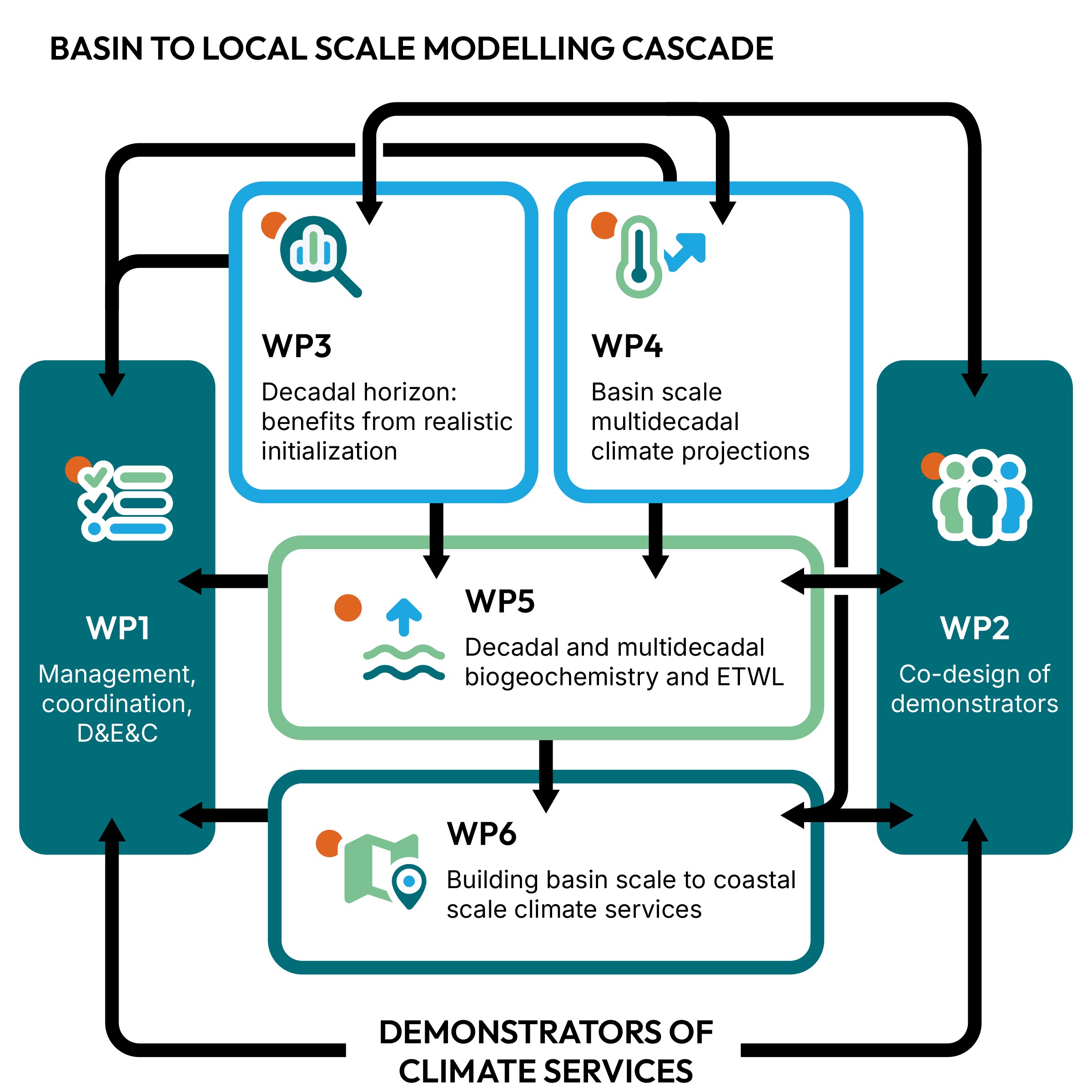
RIVIERADE’s work is organised across six closely connected work packages, each with a clearly defined role, a lead and a co-lead institution and area of responsibility.

Lead: OGS
WP1 ensures the effective scientific, technical, financial and administrative coordination of the project. It also manages data, communication, dissemination and exploitation activities to maximise the visibility, uptake and long-term impact of RIVIERADE’s results.

Lead: ENEA | Co-lead: SMHI
WP2 brings scientists, stakeholders and end-users together to co-design climate service demonstrators for the three target seas. It guides their development, testing and validation, ensuring that the resulting services respond to real decision-making needs from basin to coastal scales.

Lead: CMCC | Co-lead: IOW
WP3 develops and evaluates downscaling approaches to produce high-resolution climate predictions for the next ten years. By combining realistic initialisation with information from CMEMS, DCPP and other sources, it strengthens regional predictions for the Baltic, Black and Mediterranean Seas.

Lead: CNRS/MF | Co-lead: ULiege
WP4 develops a coordinated grand ensemble of high-resolution, multi-model and multi-sea climate projections for the Baltic, Black and Mediterranean Seas. Building on the CORDEX expertise, it assesses how the physical conditions of the three seas may evolve over the coming decades, quantifies uncertainty and prepares standardised outputs for wider scientific use.

Lead: OGS | Co-lead: IHE DELFT
WP5 builds a first-of-its-kind coordinated ensemble for two complementary dimensions of marine change: biogeochemistry and extreme total water levels ETWL. It assesses how marine ecosystem conditions may evolve, while also combining projected sea-level rise with tides, storm surges, wave setup and land movement to examine future coastal extremes across the three target seas.

Lead: METU | Co-lead: CNRS/UT
WP6 translates decadal predictions and climate projections into indicators, products and services for ocean health, the blue economy and coastal risks. It develops basin-scale information for all three target seas and high-resolution use cases in the Northern Adriatic, Southern Black Sea, Marmara Sea and along the Swedish Coast.